Category Archives: geoserver

Coastlines fascinate

Seems like I am pulled to the coastlines. Seems like I am not alone. People tend to gravitate towards food resources, and where the ocean meets land, and even rivers, food has always been plenty. Trade too. And the boats of course.

I have a house, in the northern parts of Norway where the shoreline is but 200 meters away. From where I live in Trondheim I can see the fjord. The ocean has  always been around.

I am one of those with fond memories of small waves, a grandfather safely steering the boat, and days blessed with sun and fishing. When the weather was less than fair we stayed in or near my grandparents house enjoying our small adventures around the old farm.

Seems also that the places I travel to these days are close to the ocean. Zanzibar is one of these fantastic places where oportunities and challenges arise practically on the shoreline. Mapping those oportunities and challenges is part of what I do. It invoves drones, big databases, partners in many institutions, researchers and more. Sometimes it comes together in a map describing the sensitivities of a coastal area. I like the thought of it, but fear that we more often than not do not have enough knowledge to present detailed enough maps.

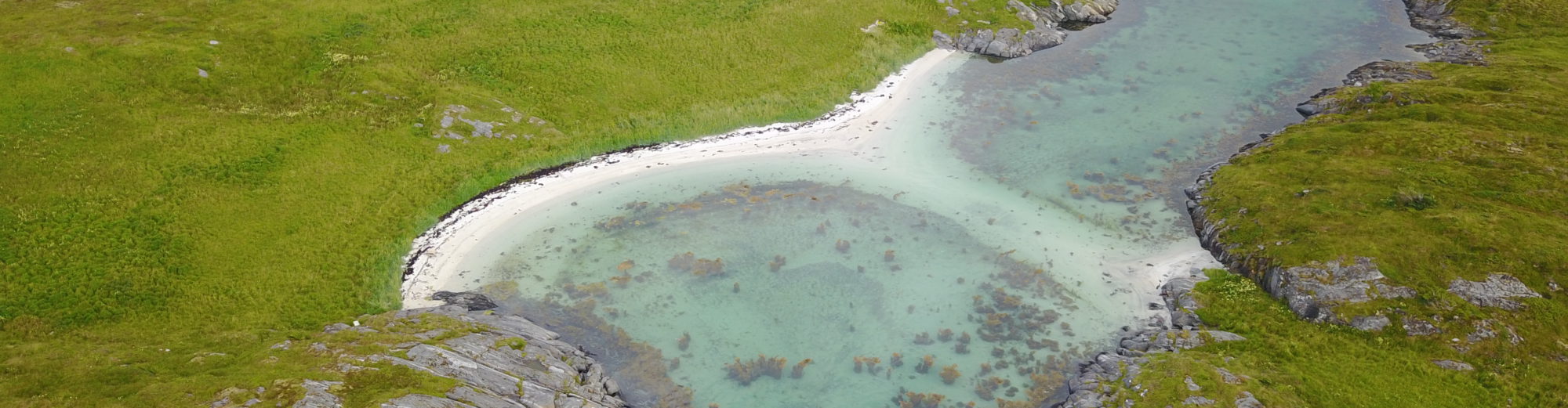
In September we took some time off from our QGIS workshop to play around with the EPA drone. Great fun in the tennis court.

Ghana is an other of those places. My stays are usually in Accra, and although the coastline is

never far away it is merely the frame of the ocean and not much more. Inaccessible because of restricted daytime for me, the workshop participant and meetings participant. Workshops outside Accra usually end up being in Sogakope, a 60 minute drive down to Keta. But my meetings usually revolve on issues related to the ocean and its shoreline.

What’s with the coastal areas then? Here are some of the processes I am involved in:

  • Environmental atlases
  • Coastal sensitivity analysis for emergency response
  • Digitalization of drone data in coastal areas (coastline/mangrove/substrate)
  • Methods development of sensitivity assessments (both coastal and terrestrial)

I have attached a video from a recent (September 2017) trip to the Keta Lagoon area in Ghana. On a small strip of land between the Keta Lagoon and the coastline thousands of people live their lifes. The inland areas which are not flooded (remember this is a lagoon) are occasionaly flooded rendering the areas uninhabitable for parts of they year.

In the video you can see the sand traps designed to “harvest”sand so that the thin strip does not erode. You can see this as big dumps of stone perpendicular to the shoreline.

Apart from letting us see some of the areas near the coast the video also shows some highlights form a QGIS training near Sogakope.

Clearinghouse for the environment – the girders (II)

In February 2012 I wrote about “Environmental Spatial Data Infrastructure” on this blog. Later that year the case complex matured somewhat and in August I wrote the posting “Clearinghouse for the environment – the scaffolding (I)“.

Since then I have together with my colleagues had the opportunity to test systems in full scale by contributing to the implementation of clearinghouses in partner countries.

Last time I showed how a stack consisting a hardware layer with vmWare as one of the basic modules could form the basis of an environmental spatial data infrastructure. In some ways this was a rather optimistic setup.

A stack of hardware and software which could become very usefull...

Some of our main challenges with the above set up was maintenance of physical equipment. So we removed that layer. Maintaining a complex setup with a virtual machine environment, or getting access to local environments proved in general to be difficult. So we ditched it.

To get the systems running we needed:

  • Shared access to the systems for administrative purposes
  • A flexible backup-system
  • An option to duplicate successful setups
  • Scalability
  • High availability
  • Flexible security system

Other things we considered important

  • The system should not tie our partners up in future licensing costs
  • Compliance to central standards
  • An option for partners to move the systems to physical infrastructure if necessary
  • Option to keep traffick outside our own company networks – since they are de-facto external systems paid for by external partners

As you all can see in all a lot of considerations which we had to relate to.

AWS_LOGO_CMYK-588x214Since internet access across borders in any case would be relevant for retrieving external map layers we started looking at how we could use Amazon services. I already had experience in running virtual macines using Amazon EC2. Amazon helped us out with many of the issues mentioned above. So in short we moved the whole setup to Amazon. The following figure illustrates the setup.

sdi_onestop_amazon

In addition to the components relying on EC2 we have also found that using Amazon Simple Storage (S3) for storing survey data of some size could be a good ide. S3 allows the user to distribute files using “secure” links and even using the bit-torrent protocol for files up to 5 Gb.

We now have one such system built up and under testing. It looks good but as always the technology is but a small part of the equation. Establishing information flows, using standards etc represents the major parts of a national envoronmental spatial data infrastructure.

Should the need arise to develop custom made solutions it should be possible to add more virtual machines in the setup.

sdi_onestop_amazon

Given that our partners find this setup trustworthy we will probably suggest this as an entry level spatial data infrastructure for environmental data.

WordPress directly, and through countless plugins, supports many standards for embedding information. How information should flow between the different systems in this setup has been given some thought. I will try to elaborate on this in a later posting – hopefully in less than two years time.

Integrating the OGC WMS getcapabilities information in WordPress (iframe)

wms_tools_codeOver the last two years I have worked with WordPress as a content management system for several projects. WordPress has proved to be a flexible platform for publishing documents, files in general, imagery and maps. There was one thing missing though. I wanted to be able to list map layers available on a given wms-server.

To solve this I have now made a small php-script which allows the user to integrate server capabilities information from a geoserver based WMS-server. The code is a work in progress and does admittedly have some shortcomings.

The feature would not be possible without wms-parser.php and Openlayers. Continue reading

Geoserver as a tool for providing networked geospatial environmental data

As a geographer I once in a while end up being extremely positively surprised by innovations, both commercial and from open source communities. Google Earth, which most of us know, has opened the world of GIS in a completely new way for the general public. The ESRI products from desktop to server has been a mainstay for years. Geoserver is another door opener – it is not new, but it has grown in professionally the last few years.

Although Geoserver will not find the same audience as Google Earth it helps by leveling the field when it comes to providing spatial data by the use of servers. Where one earlier would need detailed knowledge (and funding) to set up ESRI products, one may now do the same investing only a couple of hours of work. Within hours you could be able to present spatial data within your own organization, or even externally using a web server. Continue reading